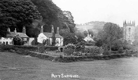
| Pott Shrigley is a delightful hamlet located about one mile northeast of the small town of Bollington in northeast Cheshire. It’s as rural as you can get with the buildings that form its centre huddled close to the top end of two valleys, overlooked by Holme and Nab woods on the higher ground and enjoying views of hills to the southwest. In all directions there are beautiful trees, fields, often with grazing sheep, and at the centre, St Christopher’s Church |
 |
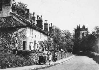 |
There are three roads to the church, where they join – the road to Bollington, a road up Bakestonedale leading to Kettleshulme and Whaley Bridge, and the road past Shrigley Hall hotel to Adlington. These are busy roads but the very sharp corner round the church, and the junction, ensure that nothing speeds through this lovely place. The 392 bus route passes through with a convenient stop right by the church. The only street lamp is a Victorian gas lamp lighting(?) the corner by the church. |
 Pott Shrigley is known for a couple of outstanding things other than its church and school – in Spring the bluebells along the road up the hill towards Shrigley Hall are a sight to behold; the best for miles, fantastic show. The other notable item is the cricket club. This must be one of the most beautiful settings for a cricket ground anywhere in the world, truly stunning. And the field makes a superb location for the extremely popular annual bonfire and firework display every 5th of November (actually the nearest Saturday).
Pott has a long and interesting history. It has had for centuries a grand house, Shrigley Hall, which has been occupied by some influential people over time such as the Downes (for 500 years) and the Lowthers. The present building was built by William Turner, a Blackburn industrialist, in the 19thC. Shrigley gave its name to the Shriggley family – or was it the other way around? The Turner family were the subject of a 19thC tragedy, beautifully described in a book, The Shrigley Abduction (see below). In 1817 there was note of the name being Pott-within-Shrigley (a Macclesfield newspaper, 20/09/1817)
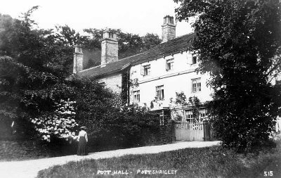
Pott Hall (pictured above) is another fine house which has been re-developed in the early part of the 21st century and is now a number of domestic houses and apartments. Prior to that it was used for many years as a care home.
The house with the pretty windows opposite Pott Hall was at one time a pub called the Lowthers Arms. Before it was a pub it was Pott Hall Farm (thanks Jo Hadfield). Read about it.
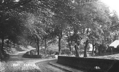 A quarter mile along the Bollington road is another small group of houses at a spot known as Walkersgreen (left). Here the original road to Bollington branches off to the left. Today it’s just another, but very pleasant, way to Bollington. A long time ago it carried on into Oakenbank Lane and went all the way to Rainow, today a very nice walk.
The direct road to Bollington, off to the right, is particularly straight and level and is known as Pott Levels. The central section from the Vicarage to the top of Shrigley Brow in Bollington was built in the 19thC to provide an easier route than going over the ups and downs of Spuley Lane and Smithy Brow. This mattered to Hammonds who had a coal/clay mine and brick making operation up Bakestonedale Road. Their customers and long distance transport were all at Bollington and such heavy loads needed an easy road in the days of the horse and cart! Their wagons were so heavy that the road base was laid with tree trunks across it all along the soft ground of the levels. They remain the foundation for the road to this day.
There is a fine stream running through the centre of Pott originating a mile away up on Bakestonedale.
Books
A number of books have been written about Pott Shrigley, its community and history, and these are listed on the Books page![]() .
.
Links
YouTube video of church![]() | ‘Walking in Pott Shrigley’ footpath map | School web site
| ‘Walking in Pott Shrigley’ footpath map | School web site![]() | Parish Council web site
| Parish Council web site![]() | St Christopher’s Church web site
| St Christopher’s Church web site![]() | Craig Thornber’s page
| Craig Thornber’s page![]() | Conservation Area Appraisal (carried out by the Peak District National Park)
| Conservation Area Appraisal (carried out by the Peak District National Park)![]() .
.