The Bollington Outdoors website is now here …
 In 2017 Neville Bester and Linda Stewart developed a popular walking website called Bollington Outdoors. This was a compliment to their two walking booklets, Walks from the Vale Inn, and Walks from the Poachers Inn. Since Neville moved out of Bollington, he decided to discontinue the website. Fortunately, he has been so kind as to provide the content to the happyvalley website so that we can include it in its own section.
 Bollington is well known to provide access to truly wonderful walking country. Located on the western edge of the Peak District National Park
![]() , an area known as the Cheshire Peak District
, an area known as the Cheshire Peak District![]() , it offers walks amongst the low hills and valleys, leading up to higher ground or through to Macclesfield Forest
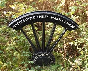
, it offers walks amongst the low hills and valleys, leading up to higher ground or through to Macclesfield Forest![]() . In the opposite direction there are many footpaths into the flatter lands of the Cheshire Plain. Bollington also has both the Macclesfield Canal and the Middlewood Way (right) passing through – both offer countless miles of level walking, out on one, back on the other. The variety of walks described nowhere near exhausts all the possibilities, but offer choices to suit everyone, from those short mainly level strolls to lengthy up and down hill walks to suit the well equipped experienced adventurer. Each is listed here in summary with links to maps and a walk guide. Once you know the ground, with a bit of planning it is possible to lengthen or shorten many of the walks to better suit your purpose.
. In the opposite direction there are many footpaths into the flatter lands of the Cheshire Plain. Bollington also has both the Macclesfield Canal and the Middlewood Way (right) passing through – both offer countless miles of level walking, out on one, back on the other. The variety of walks described nowhere near exhausts all the possibilities, but offer choices to suit everyone, from those short mainly level strolls to lengthy up and down hill walks to suit the well equipped experienced adventurer. Each is listed here in summary with links to maps and a walk guide. Once you know the ground, with a bit of planning it is possible to lengthen or shorten many of the walks to better suit your purpose.
Bollington holds a Walking Festival each year in September
Next Walking Festival : 4-13 September 2026
 Many footpath maps and walks guides are available from the Discovery Centre , and from the Bridgend Centre
![]() .
.
Three free leaflets are available at the Discovery Centre for self guided walks that leave from the centre. Please pop in and help yourself to these.
Bollington Civic Society and the Discovery Centre organise guided heritage walks as part of the Bollington Walking Festival![]() held in late September each year. Some start from the Bridgend Centre, others from other locations. Please see the Walking Festival page
held in late September each year. Some start from the Bridgend Centre, others from other locations. Please see the Walking Festival page![]() for details. We sometimes organise heritage walks in the summer months. See the Civic Society page for details.
for details. We sometimes organise heritage walks in the summer months. See the Civic Society page for details.
Many guided walks are organised by the Bridgend Centre![]() . They have a programme of fortnightly walks – see their web page for details. They also provide self guided walks which require the relevant guide pack – there are presently seven to choose from! These are available for purchase from the Bridgend Centre or the Discovery Centre at a nominal price. Many of these walks are specially designed for children and are therefore short and easy but always with added interest for children including spotting the specially designed way markers. A favourite destination is White Nancy on top of Kerridge hill. We have a page providing guidance for walking to Nancy.
. They have a programme of fortnightly walks – see their web page for details. They also provide self guided walks which require the relevant guide pack – there are presently seven to choose from! These are available for purchase from the Bridgend Centre or the Discovery Centre at a nominal price. Many of these walks are specially designed for children and are therefore short and easy but always with added interest for children including spotting the specially designed way markers. A favourite destination is White Nancy on top of Kerridge hill. We have a page providing guidance for walking to Nancy.
For those wanting to walk further into the Peak District, have a look at the walks guides on the ’10 Adventures’ Hikes in Peak District![]() website.
website.
For each of the following walking suggestions we have provided a What3words navigation tag for the start point.
Walk 1: Bollington to Rainow via Rainowlow
Start/Finish: Ingersley Vale, Bollington; ///hears.archduke.though![]() . Distance: 3.2 miles (5.1 km). Difficulty: Easy to Medium. Ascent: 156m. Time: 1 to 1½ hours.
. Distance: 3.2 miles (5.1 km). Difficulty: Easy to Medium. Ascent: 156m. Time: 1 to 1½ hours.
Walk 2: Pott Shrigley to Lyme Park
Start/Finish: Layby at the side of Shrigley Road, Pott Shrigley, opposite a house named Needygate; ///depth.magazine.yummy![]() . Distance: 4.8 miles (7.6 km). Difficulty: Medium. Ascent: 158m. Time: 2 to 2½ hours.
. Distance: 4.8 miles (7.6 km). Difficulty: Medium. Ascent: 158m. Time: 2 to 2½ hours.
Walk 3: Bollington to Rainow and Kerridge
Start/Finish: Ingersley Vale, Bollington; ///hears.archduke.though![]() . Distance: 5.2 miles (8.4 km). Ascent: 208m. Difficulty: Easy to Medium. Time: 2 to 2½ hours.
. Distance: 5.2 miles (8.4 km). Ascent: 208m. Difficulty: Easy to Medium. Time: 2 to 2½ hours.
Walk 4: Bollington, Higher Hurdsfield and Rainow
Start/Finish: Jackson Lane, Kerridge; ///straws.regretted.surface![]() . Distance: 5.8 miles (9.3 km). Ascent: 321m. Difficulty: Easy/Moderate. Time: 2 to 2½ hours.
. Distance: 5.8 miles (9.3 km). Ascent: 321m. Difficulty: Easy/Moderate. Time: 2 to 2½ hours.
Walk 5: Higher Hurdsfield and Bollington Circular
Start/Finish: Kerridge Road, Higher Hurdsfield; ///strain.clear.shared![]() . Distance: 5.8 miles (9.4 km). Ascent: 200m. Difficulty: Mainly medium, one short climb. Time: 2 to 2½ hours.
. Distance: 5.8 miles (9.4 km). Ascent: 200m. Difficulty: Mainly medium, one short climb. Time: 2 to 2½ hours.
Walk 6: Bollington, Adlington
Start/Finish: Car park on Clough Bank; ///laminated.outreach.shout![]() . Distance: 9.0 miles (14.5 km). Difficulty: Mainly medium, one long climb. Ascent: 387m. Time: 3½ to 4 hours.
. Distance: 9.0 miles (14.5 km). Difficulty: Mainly medium, one long climb. Ascent: 387m. Time: 3½ to 4 hours.
Walk 7: Bollington to Lyme Park
Start/Finish: Middlewood Way Car Park, Adlington Road, Bollington; ///paddle.chill.procured![]() . Distance: 10.3 miles (16.6 km). Difficulty: Mainly medium, a few small inclines. Ascent: 376m. Time: 3½ to 4 hours.
. Distance: 10.3 miles (16.6 km). Difficulty: Mainly medium, a few small inclines. Ascent: 376m. Time: 3½ to 4 hours.
Walk 8: Bollington to Whiteley Green
Start/Finish: Middlewood Way Car Park, Adlington Road, Bollington; ///paddle.chill.procured![]() . Distance: 1.75 miles (3.0km). Difficulty: Easy. Ascent: 38m. Time: 1 to 1½ hours.
. Distance: 1.75 miles (3.0km). Difficulty: Easy. Ascent: 38m. Time: 1 to 1½ hours.
Walk 9: Bartons Clough and Styperson
Start/Finish: Middlewood Way Car Park, Adlington Road, Bollington; ///paddle.chill.procured![]() . Distance: 4.0 miles (6.4 km). Difficulty: Easy, no major climbs. Ascent: 108m. Time: 1½ to 2 hours.
. Distance: 4.0 miles (6.4 km). Difficulty: Easy, no major climbs. Ascent: 108m. Time: 1½ to 2 hours.
Walk 10: Bollington to Swanscoe
Start/Finish: Jackson Lane, Kerridge; ///straws.regretted.surface![]() . Distance: 3.2 miles (5.1 km). Difficulty: Easy, no major climbs. Ascent: 105m. Time: 1 to 1½ hours.
. Distance: 3.2 miles (5.1 km). Difficulty: Easy, no major climbs. Ascent: 105m. Time: 1 to 1½ hours.
Walk 11: Three Peaks Challenge
Kerridge Hill – White Nancy – The Nab
Start/Finish: Middlewood Way Car Park, Adlington Road, Bollington; ///paddle.chill.procured![]() . Distance: 7.6 miles (12.2 km). Difficulty: Tough, major climbs. Ascent: 400m. Time: 3 to 3½ hours. There is an annual hill race covering most of this route – the winner does it in just over 40 minutes!
. Distance: 7.6 miles (12.2 km). Difficulty: Tough, major climbs. Ascent: 400m. Time: 3 to 3½ hours. There is an annual hill race covering most of this route – the winner does it in just over 40 minutes!
A selection of walks beginning and ending at the Poachers Inn.
Walk Poachers 1: Short Route
Start/Finish: The Poachers Inn, Ingersley Road, Bollington; ///thunder.roadshow.prank![]() . Distance: 4.2 miles (6.7 km). Difficulty: Mainly medium, two short climbs. Ascent: 185m. Time: 1½ to 2 hours.
. Distance: 4.2 miles (6.7 km). Difficulty: Mainly medium, two short climbs. Ascent: 185m. Time: 1½ to 2 hours.
Walk Poachers 2: Medium Route
Start/Finish: The Poachers Inn, Ingersley Road, Bollington; ///thunder.roadshow.prank![]() . Distance: 5.8 miles (9.3 km). Difficulty: Mainly medium, two short climbs. Ascent: 279m. Time: 2 to 2½ hours.
. Distance: 5.8 miles (9.3 km). Difficulty: Mainly medium, two short climbs. Ascent: 279m. Time: 2 to 2½ hours.
Walk Poachers 3: Long Route
Start/Finish: The Poachers Inn, Ingersley Road, Bollington; ///thunder.roadshow.prank![]() . Distance: 6.9 miles (11.1 km). Difficulty: Mainly medium, one short climb. Ascent: 338m. Time: 2½ to 3 hours.
. Distance: 6.9 miles (11.1 km). Difficulty: Mainly medium, one short climb. Ascent: 338m. Time: 2½ to 3 hours.
A selection of walks beginning and ending at the Vale Inn.
Walk Vale 1: Short Route
Start/Finish: The Vale Inn, Adlington Road, Bollington; ///page.dugouts.outer![]() . Distance: 4.6 miles (7.5 km). Difficulty: Mainly medium, two short climbs. Ascent: 200m. Time: 1½ to 2 hours.
. Distance: 4.6 miles (7.5 km). Difficulty: Mainly medium, two short climbs. Ascent: 200m. Time: 1½ to 2 hours.
Walk Vale 2: Medium Route
Start/Finish: The Vale Inn, Adlington Road, Bollington; ///page.dugouts.outer![]() . Distance: 6.3 miles (10.2 km). Difficulty: Mainly medium, two short climbs. Ascent: 299m. Time: 2¼ to 2¾ hours.
. Distance: 6.3 miles (10.2 km). Difficulty: Mainly medium, two short climbs. Ascent: 299m. Time: 2¼ to 2¾ hours.
Walk Vale 3: Long Route
Start/Finish: The Vale Inn, Adlington Road, Bollington; ///page.dugouts.outer![]() . Distance: 7.4 miles (11.9 km). Difficulty: Mainly medium, one short climb. Ascent: 356m. Time: 2½ to 3 hours.
. Distance: 7.4 miles (11.9 km). Difficulty: Mainly medium, one short climb. Ascent: 356m. Time: 2½ to 3 hours.
The Cheshire Peak District
There is a vast number of walks in the wider district, known as the Cheshire Peak District, and the following video walks produced by Neil O’Connor are particularly enjoyable. He also has a Facebook page![]() .
.
Acknowledgements
All credit must go to Neville Bester and Linda Stewart for their work in developing and recording each walk. Over 96 miles of walks – must have required a lot of pints!
Ordnance Survey maps, Crown copyright, reproduced with permission under licence 100050140.