‘Old’ Bollington | West Bollington | Bollington Cross | Lowerhouse | Gnathole | Kerridge | Ingersley
The present day town of Bollington has evolved over the centuries firstly from a number of scattered farms and small groups of houses and secondly from three small villages that coalesced the original centres of agriculture. So we have ‘Old’ Bollington in the east, West Bollington in the middle and Bollington Cross in the south, strung along two miles of road. In addition, there is the outlying area of Lowerhouse at the bottom end of Albert Road and Gnathole at the end of Adlington Road. Hanging over all is Kerridge which retains its individuality as well as its name. Because of the layout of these parts, the resulting town is very long and narrow; two miles from end to end but generally not very wide, controlled to some extent by the geography of the valleys within which the town is built. Ingersley is not really a part of Bollington, being in Rainow parish. However, Ingersley Vale is very important to Bollington. And the most important part of all is our very own White Nancy sitting on top of Kerridge Hill! And we had better not forget the other hill that overlooks us, The Nab.
‘Old’ Bollington
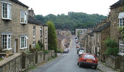
 Old is in quotes because it is not formally used in the name. But it is used locally to differentiate this part of the town. Also commonly called ‘Top End’. This is the largest part of the town and was developed in the 19thC with the coming of the mills and quarries. As a result most of the buildings are built of stone – hence another local term; the stone end of Bollington. The mills in ‘Old’ Bollington included Defiance mill (Queen Street), Higher mills and Lower mills (both at the end of Church Street), Oak Bank mill (now Hamson Drive), Clarence mill (top of Clarence Road), and Whitaker’s or Bannister’s Owlhurst mill (Turner Street). The mills of Ingersley Vale have a page to themselves. Clarence mill houses the Civic Society’s Discovery Centre .
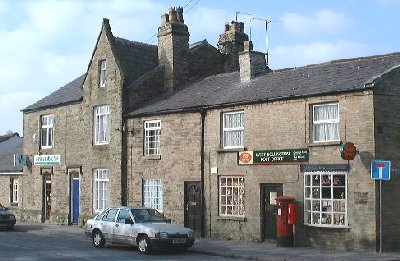
Other notable locations include St. John’s Church; the main shopping areas of High Street (above) and Palmerston Street; Water Street with its fantastic hanging baskets and window boxes in the summer, the old Water Street school building, now the Water Street Centre![]() , and the river Dean tunnel (really!)
, and the river Dean tunnel (really!)![]() ; Pool Bank – more interesting in the past, when it was really a pool, rather than its unattractive look today, as a car park; Beeston quarry with the old Oak Bank mill chimney and the Lookout on top of its cliffs; Bridge End and its historic buildings including the Bridgend Centre
; Pool Bank – more interesting in the past, when it was really a pool, rather than its unattractive look today, as a car park; Beeston quarry with the old Oak Bank mill chimney and the Lookout on top of its cliffs; Bridge End and its historic buildings including the Bridgend Centre![]() ; Queen Street, probably the most original and quaint street in town; the war memorial gardens; Coronation Gardens (younger children’s playground), Rock Bank House; Limefield House; Beeston Brow. Buried in the midst of all this is the major employer in the town, Tullis Russell and their paper coating mill at Lower mill.
; Queen Street, probably the most original and quaint street in town; the war memorial gardens; Coronation Gardens (younger children’s playground), Rock Bank House; Limefield House; Beeston Brow. Buried in the midst of all this is the major employer in the town, Tullis Russell and their paper coating mill at Lower mill.
The Macclesfield Canal aqueduct across Palmerston Street is normally regarded as the divide between ‘Old’ Bollington and West Bollington, though the railway viaduct is really a more sensible divide because the buildings between the two transport crossings are really in the style of ‘Old’ Bollington. I will use the latter and include other notable locations such as St. Gregory’s Church; the Methodist Church; the Town Hall; the Arts Centre; the 1970s Civic Hall with the Library beneath; the course of the old railway, now known as the Middlewood Way; the Recreation ground; the small community at the end of Adlington Road (see Gnathole below).
Along Shrigley Road there is a 1960/70s housing development generally known as the Nab estate. This provides access to Nab hill, otherwise known as ‘The Nab’.
The land encompassed by Cumberland Drive, Lord Street, Chancery Lane and High Street has been developed, as has the old canal wharf part way up Hurst Lane, and a plot of land against the canal in Highfield Road.
West Bollington
 This part of town is dual centred, on Wellington Road at its junction with Garden Street and Hawthorn Road (left), and a couple of hundred metres west around the Bayleaf Indian restaurant on the junction of Wellington Road, Henshall Road, Grimshaw Lane. The oldest building here is Bollington Hall Farm, half way between the two centres. While stone is used in many buildings, brick is also commonplace with some buildings using it for back and sides and the more modern houses being all in brick. However, the mills were built in stone. The only one remaining here is Adelphi mill. Waterhouse mill was demolished in the 1960s and replaced with the then modern Kay Metzler factory, and more recently by the Waterhouse estate.
Notable locations include the Waterhouse Medical Centre, Brook House, Albert Road leading to Dean Valley Primary School and Lowerhouse, Grimshaw Lane leading to Bollington Wharf on the Macclesfield Canal, and St. John’s Primary School, and on to Kerridge.
Going up the hill on Henshall Road towards the junction with South West Avenue marks the boundary with Bollington Cross.
West Bollington is divided by the Middlewood Way, a ten mile nature trail on the old railway track.
Gnathole – Adlington Road
Tucked into a corner known as Gnathole, a dozen houses at the end of Adlington Road huddle against the boundary with Adlington. Lodge Brow rises above them on one side, the trees of Swinerood wood rise on another. They look out across the recreation ground with a backdrop of Kerridge Hill and White Nancy. A truly delightful spot – in spite of the name! Between Adlington Road and the Middlewood Way is the older-children’s playground offering a variety of swings and roundabouts, together with a very popular skate park, and room for ball games. There is a small car park adjacent to the games area and access to the Middlewood Way, and a new (in 2017) path under the viaduct and over the river into the Waterhouse estate, giving access to Wellington Road.
Almost unseen a small stream runs in a stone built culvert beneath the houses and all the way across the children’s playground, under the railway viaduct and only re-appears where it drains into the river Dean. Not a lot of people know that!
Lowerhouse
This delightful hamlet was created as a model mill village. Although the mill and the main body of cottages were built by Philip Antrobus, around 1818, the ‘community’ of Lowerhouse was the creation of Samuel Greg Jnr who not only developed the Lowerhouse mill from 1832 but also built many of the houses and the library/school for his workers. He provided them with allotments and encouraged them to grow their own vegetables.
The mill has been in almost continuous use since 1818 but most regrettably its occupant for many decades, Henry & Leigh Slater, closed down in January 2025. The mill has its own mill pond, used only for fishing today. For many years there was a sand quarry in the field behind the mill and this area was re-developed as the Borough Council’s amenity (re-cycling) centre. This was closed in 2024 despite much protest. The meadows between the mill and the ‘tip’ were the subject of strongly contested planning applications, resulting firstly in a new industrial development being started in late 2006, but then abandoned, and then the development of housing on both sides of the road from 2016.
Moss Brow is one of the original lanes in the area, once part of Moss Lane, remaining unchanged, except for its metalled surface, perhaps for more than 1,000 years, and leading to Bollington Cross. For about 50 years this was the only access to Lowerhouse mill, until Albert Road was built in 1868.
Bollington Cross
 Buildings along Henshall Road and Bollington Road, through Turner Heath, mark the old stone part of this end of town. However, the majority of houses are relatively modern – 20thC – arranged in two large estates, known as South West Avenue and Ovenhouse Lane, which are actually adjacent to each other. There was never any industry other than agriculture in Bollington Cross – no mills (with one small exception, see Turner Heath mill), no quarries – it has always been entirely domestic. Some farms in this area have been in the same hands for centuries – Ovenhouse Farm was held by the Normansell family for c.2 centuries from the mid-16thC, the Shatwall/Shatwell family has farmed in this area for around 700 years!
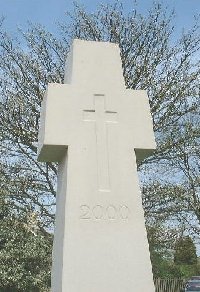
The cross is marked today by the new stone cross erected for the millennium (left). The stone was quarried from Bridge Quarry, Kerridge, on the side of Kerridge Hill. Mrs. Doreen Earl fashioned it on her computer controlled stone dressing machine into the beautiful monument you see today. The embellishments are not carved but sand blasted.
Notable sites include Bollington Cross School; St. Oswald’s Church; the Cock & Pheasant inn (the only one at this end of the town) with the Greg Fountain opposite; Turner Heath House; Barley Grange (used to be the Barley Mow pub); the new cross (pictured); Bollington Leisure Centre; The Mount – once the Greg family home, now a care home in Flash Lane.
There is a very strong desire locally to maintain a green strip between Bollington Cross and Tytherington – Bollington is very certain that it does not want its individuality and identity to be subsumed by the urban sprawl that is Macclesfield. “Bollington, a place in its own right!”!