 |
Albert Road was constructed in the 19th century when Lowerhouse mill developed to the point where Moss Brow was no longer capable of handling the amount of traffic. Lowerhouse mill needed a better road that would provide more level access to other mills in Bollington. This straight almost level road connecting Lowerhouse with Wellington Road was the answer. It was paid for partly by public subscription. A stone record of this can be seen in the wall in front of the first building on the right past the junction with Riverbank Close (see below). |
Approach off Wellington Road.
Leads to Riverbank Close, Calder Close, Hartley Green, Oliver Close, Greg Avenue, Moss Brow, Moss Lane, Ridley Road, Woodlea Drive, Lowerhouse Mill, Dean Bank Close, Lowerhouse Road.
Nearest shops – West Bollington. Co-op foodstore on Wellington Road.
Nearest pubs – Bayleaf, Cock & Pheasant.
Council Ward – From Wellington Road as far as the Fire Station, Central; from the Fire Station to Lowerhouse, West.
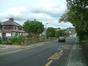
This is a busy street with housing at both ends and Dean Valley primary school, the Scout Hut, the fire station, Lowerhouse mill, and industrial premises along its length. Work began in October 2006 to build a further industrial site behind Lowerhouse Mill. However, this was abandoned and, despite much opposition, planning applications were subsequently approved to develop housing on both sides of the road to the waste collection site (closed mid-2024). The estate on the west side is now complete, but there has been no progress on the east side. Henry & Leigh Slater, the operators of Lowerhouse mill, went out of business in January 2025, and subsequently proposals have been made (2026) to develop the mill and its surroundings into a domestic estate. Part way along Albert Road the company of WK Lowe have proposed (2026) closure and site redevelopment into a large care home. The traffic load on Albert Road has decreased in recent years (to 2026) as a result of the closure of the waste collection site, Lowerhouse mill, St Gregory’s primary school, and the winding down of WK Lowe. However, traffic is expected to increase significantly with the redevelopment of the latter three sites.
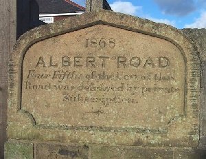 |
The memorial stone (left) records that the road was built in 1868 and that four fifths of the cost was raised by public subscription. |
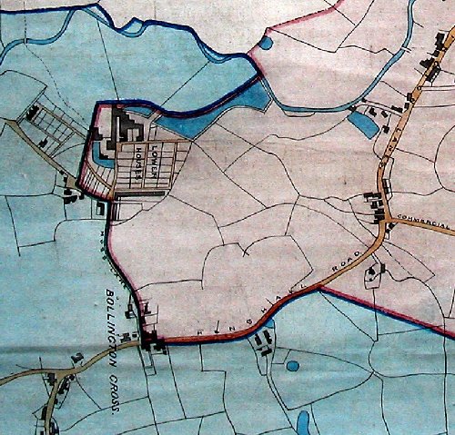 |
This old map shows Lowerhouse and Henshall Road, the main road from Bollington Cross to the rest of Bollington. Access to Lowerhouse is by Moss Brow – there was once no Albert Road! Compare with the modern map below. We also know from a 1908 property map that Albert Road terminated at the junction with Moss Brow, and that the extension around the corner was called New Road. Fortunately that most unimaginative of names was dropped and today ‘Albert Road’ extends all the way round. The Civic Society had, for many years, been pressing Cheshire East Council to make Lowerhouse into a Conservation Area. In 2021 it finally happened – Bollington Cross & Lowerhouse Conservation Area. |
Conservation
The Lowerhouse end of this street is protected by the Bollington Cross & Lowerhouse Conservation Area.
Listed structures
See Listed Buildings page for the full list and notes regarding Listed, Article 4, and SPD properties.
The links on the structures are to the Historic England web site. Any links to local history pages are to this web site.
 |
Lowerhouse mill, Albert Road |
|
") |
Lowerhouse mill Cottage, Albert Road; II, Formerly a farmhouse and barn, now two houses: 17thC. Re-located from its original position close to the mill. This listing was being reassessed and is no longer shown on the Historic England web site. | |
 |
Parish boundary stones |
|
 |
Parish boundary stone; II, in fields northeast of Lowerhouse mill, early 19thC. Not publicly accessible. |