This page provides a consolidated list of Listed buildings and other protected structures. It includes those structures noted in the Cheshire East Supplementary Planning Document (SPD) which covers all structures that should be considered valuable to the local environment but do not meet the criteria for formal Listing. These are highlighted in the table below by the SPD acronym. All items are also noted on their relevant street pages, together with buildings protected by Conservation Areas and Article 4 Directives. The street names below are linked to their relevant street page. Most links in the listed items are to the Historic England web site . ‘II’ indicates Grade II listing. Almost every piece of stonework on the Macclesfield canal is listed and they are shown separately at the bottom of the page. The monochrome pictures are historic and come from the Civic Society archive collection. The colour pictures are modern, taken by the webmasters and others. Many of the listed structures feature in other pages on this site and a link is provided in ‘(Local history page)’ at the end of the entries.
") |
|
(SPD) Bollington Conservative Club (now offices known as Adlington House); Mid 19th century Gothic. |
 |
|
Lowerhouse mill, Albert Road; II, Cotton mill built by Philip Antrobus, 1818, later occupied by Samuel Greg Jnr. (Local history page). |
") |
|
Lowerhouse mill Cottage, Albert Road; II, Formerly a farmhouse and barn, now two houses: 17thC. Re-located from its original position close to the mill. This listing was being reassessed and is no longer shown on the Historic England web site. |
 |
|
Parish boundary stones; II, in fields north of Lowerhouse mill, early 19thC. Two stones very close together. Not publicly accessible. |
 |
|
Parish boundary stone; II, in fields northeast of Lowerhouse mill, early 19thC. Not publicly accessible. |
 |
|
Heywood’s Farm, 2 & 4 Henshall Road; II, Formerly farmhouse and barn, now two houses: house 17thC, barn early 18thC all with mid 19thC alterations. |
 |
|
Orchard House, 7 Bollington Road; II, Formerly a farmhouse, now a house: early 17thC, with early 20thC alterations to the façade. (Local history page). |
 |
|
St. Oswald’s Church; II, Built 1908. |
 |
|
Barley Grange, 9 Bollington Road; II, Formerly a farm house and farm building now house: early 17thC core. (Local history page). |
 |
|
Cock & Pheasant Inn; II, Formerly a house and cottages. |
| |
|
Stables at 101 Bollington Road; II, Stables and coach house: c.1820. (Local history page). |
 |
|
Turner Heath House, 103 Bollington Road; II, Early 18thC origins, rebuilt c.1780. (Local history page).
2nd listing — ditto — |
 |
|
10 & 12 Bollington Road & Railings; II, Formerly a doctor’s house and surgery, now a house [and cottage] with raised pavement and railings to roadside. (Local history page). |
 |
|
50 & 52 Bollington Road; II, Pair of cottages, late 18thC/early 19thC. (Local history page). |
 |
|
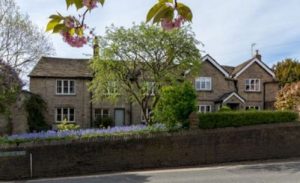
Rock Bank House; II, Formerly a house occupied by members of the Swindells family, later a war time hospital, then offices (as Carterbench House), now apartments. Built for Martin Swindells I, c.1840 (but he died before its completion). (Local history page). |
 |
|
Clarence Mill, Clarence Road; II, Cotton mill, core built c.1830s, extensively extended, original mill rebuilt 1870, further modifications 1920. (Local history page). |
 |
|
Limefield House; II, House built c.1830s for Joseph Brooke, one of the developers of Clarence Mill. Not publicly accessible. (Local history page). |
 |
|
Stables at Limefield House; II, Stables and coach house built with the house c.1830s. Not publicly accessible. |
 |
|
Briar Cottage, 4 Clarke Lane, Kerridge; II, Formerly two cottages, now a house: dated 1630 on the deeds. (Local history page). |
| |
|
Barn attached to Cold Arbour farmhouse, Clarke Lane, Kerridge; II, Formerly a corn barn, now includes a shippon and garage, 16thC. Not publicly accessible. (Off Springwood Way since construction of the Silk Road). |
| |
|
Cold Arbour Farmhouse, Clarke Lane, Kerridge; II, 16thC origins. Not publicly accessible. (Off Springwood Way since construction of the Silk Road). |
| |
|
Cold Arbour Barn, Clarke Lane, Kerridge; II, 16thC origins. Not publicly accessible. |
 |
|
Lord Clyde Inn, Clarke Lane, Kerridge; II, Formerly two weavers’ cottages, now a public house, dated 1843. |
 |
|
Endon Lodge, Clarke Lane, Kerridge; II, Formerly a lodge now a house, built c.1850. (Local history page). |
 |
|
Parish boundary stone; in field hedge east of Cow Lane, early 19thC stone marking junction of boundaries between Bollington, Rainow and Kerridge. Not publicly accessible. |
 |
|
(SPD) Greg Fountain; Gift to town from the Greg family, unveiled in 1904 in memory of Samuel Greg. |
 |
|
Rose Cottage, 58 Grimshaw Lane; II, Formerly a farmhouse now a house: 17thC with 19thC alterations. (Local history page). |
 |
|
Adelphi mill; II, Cotton mill, 1856, by Swindells brothers. (Local history page). |
 |
|
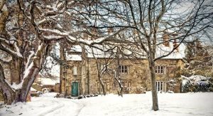
Hollin Old Hall; II, Formerly hall, then farmhouse, then divided into two houses, but now recombined into one big and very beautiful house: Early 17thC core, addition to rear and raising of roof mid 18thC for Richard Broster, further major addition c.1870 for the Ascoli family, who remodelled the whole house. |
 |
|
Boundary stone, Ingersley Road; II, in the wall opposite the Poachers Inn, early 19thC. |
| |
|
Parish boundary stone; II, close to the barn at Sowcar Farm, c.early 19thC. Not publicly accessible. There is a further stone on a field edge not far from this parish stone which has not been listed. |
| |
|
Sowcar Farmhouse; II, early 17thC. (Local history page). |
| |
|
Barn at Sowcar Farm; II, Corn barn, late 17thC. |
| |
|
Water trough; II, stone trough at the side of Sowcar Farm barn, dated 1692. |
 |
|
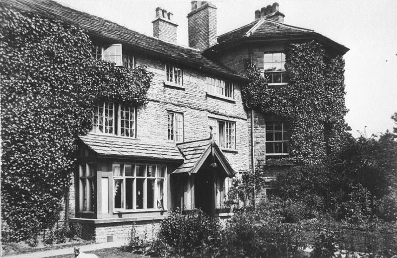
Ingersley Hall (Savio House); II, Formerly Ingersley Hall now religious house [Savio House]: earliest house c.1775 for John Gaskell, remainder 1833 for John Upton Gaskell. (Local history page). |
| |
|
Conference Hall at Ingersley Hall; II, Formerly coachhouse now a hall: c.1850 for John Upton Gaskell with alterations and additions to rear of c.1950. |
| |
|
The Cottage at Savio House; II, Formerly farmhouse now hostel: late 18thC with addition to right dated 1850 and 20thC alterations. |
 |
|
(SPD) Lowther Street School; Mid 19th century Gothic style school house. Restored and converted into apartments early 21stC. |
| |
|
36 & 38 Oak Lane, Kerridge; II, Formerly two houses now a house, built late 18thC. |
 |
|
Stables at Endon Hall, Kerridge; II, Stables and coach house for William Clayton, c.1835. Not publicly accessible. |
| |
|
Icehouse in Endon Hall garden, Kerridge; II, Icehouse: c.1840 for William Clayton. Not publicly accessible. |
 |
|
Kerridge War Memorial, Oak Lane, Kerridge; II, 1919, private war memorial constructed by the people of Kerridge. Local history. |
 |
|
Holly Bush Inn; II, Converted to present form c.1935 and is one of few examples of an urban pub from the inter-wars years. This building has been listed in March 2014 in order to protect it and its notable interior. Interior not publicly accessible outside opening hours. |
| |
|
39A, Palmerston Street; II, Former house, now office associated with [JJJ Heathcote’s] shop, c.1840. |
 |
|
Bollington War Memorial; II, 1920, A sandstone cross set in memorial gardens. Local history. |
 |
|
(SPD) 81 & 83 Palmerston Street; A pair of mid 19th century, double fronted, semi-detached houses. |
 |
|
Parish boundary stone, Shrigley Road; II. The original 18thC stone was seriously damaged in a road accident and has been replaced in June 2009 with a new and larger stone bearing the same inscription as the original – S (Shrigley) on one face, B (Bollington) on the other. The stone stands at an angle to the road because the boundary crosses the road at that angle! |
 |
|
The Vicarage, Shrigley Road; II, 1898 by Ernest Newton. Not publicly accessible. |
| |
|
Parish boundary stone; II, in fields northeast of Nab, early 18th/19thC. Not publicly accessible. |
 |
|
The Owlhurst (mill); II, c.1865; Formerly Whittaker’s flour bag mill, later Bannister’s Joinery Workshop; late 20thC gutted by fire, before conversion to domestic. (Local history page). |
 |
|
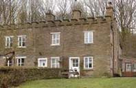
Bollington Hall Farmhouse, 83 Wellington Road; II, 16thC origins. (Local history page). |
 |
|
Methodist Church, Wellington Road; II, 1886 by William Waddington of Manchester. (Local history page). 1980s divided horizontally by the insertion of an intermediate floor. Early 21stC de-consecrated, re-purposed for commercial activities. |
 |
|
(SPD) The Manse, 27 Wellington Road; stone Victorian Methodist minister’s house. |
 |
|
(SPD) Railway viaduct; 1869, part of the Macclesfield, Bollington & Marple railway, now the Middlewood Way. |
 |
|
(SPD) Brook House and Outbuilding, 53 Wellington Road; C.1860 handsome double-fronted Victorian house, stone with stucco render. (Local history page). |
 |
|
(SPD) 55-63 Wellington Road; Mid 19th century Gothic terraced houses. |
 |
|
4, 6 & 8 Turret Cottages, Windmill Lane; II, Formerly two cottages and a smithy, now three cottages, c.1840 for William Clayton. |
 |
|
‘Chimney’, Windmill Lane; II, 19thC, thought to have been a part of William Clayton’s coal mining business. Now known not to have been a chimney and believed to have been built as a folly. |
 |
|
Kiln, Windmill Lane; II, Potash or lime kiln, probably late 18thC. |
 |
|
Estate boundary stone; II, dividing two quarries on Kerridge Hill, 1830. Not publicly accessible. |
, Windmill Lane, Kerridge") |
|
Parish boundary stone; II, in the wall at Ivy House (now called Marksend House), Kerridge Road, Marksend, late 18thC, early 19thC. |
 |
|
Canal bridge No.26, over Macclesfield Canal, Sugar Lane; II, c.1830 by William Crosley, engineer. |
 milestone, 1/2 on the other face") |
|
Quarter mile stone, Macclesfield Canal; II, on towpath between Clarence mill and Sugar Lane bridge, c.1830 by William Crosley, engineer. |
 |
|
Canal quarter mile stone; II, small stone on towpath 20m north of Palmerston street aqueduct. |
 |
|
Macclesfield Canal aqueduct over Palmerston Street; II, Built c.1830 by William Crosley, engineer. |
 |
|
Macclesfield Canal bridge no.27 under Hurst Lane; II, built c.1830 by William Crosley, engineer. Properly known as Kerridge Road bridge. |
 |
|
Macclesfield Canal milestone; II, located a few metres north from the canal access from Hawthorn Road, c.1830. |
 |
|
Macclesfield Canal aqueduct over Grimshaw Lane; II, c.1830 by William Crosley, engineer. |
 |
|
Macclesfield Canal bridge no.28; II, adjacent to Beehive Cottage (pedestrian access via Dawson Farm drive or through Tinkers Clough from Clough Bank), c.1830 by William Crosley. |
 |
|
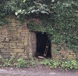
Macclesfield Canal dry dock; II, at bottom end of the ‘Rally’ Road, dry dock and wet dock: c.1830. |
 |
|
Canal bridge No.29, over Macclesfield Canal, Clarke Lane; II, c.1830 by William Crosley, engineer. |
 |
|
Canal milestone south of bridge 29, Clarke Lane; II, c.1830 by William Crosley, engineer. |
Other forms of protection
‘Listing’ is the process used by Historic England to establish protection over the most valuable examples of our built heritage. Strict rules apply to such buildings with respect to alteration, additions and the need to apply for listed building consent as well as the usual planning permission. Listing also protects the interior of the buildings where relevant.
A lesser level of protection is provided by Conservation Area designation. Again stricter planning controls exist to maintain the look and feel of a heritage area. Specific buildings within a Conservation Area may be issued with an Article 4 Directive to provide a more specific protection to the front, sides, and roof of the building. Article 4 Directives apply only to the outside of the building. They can be used to regulate styles and materials in windows and doors, and the colours used. External finishes are also controlled. Conservation Areas in Bollington and Kerridge are discussed in full on their own pages, and the relevant properties are noted on the street pages.
Cheshire East Council planners also maintain a list of buildings over which special care should be exercised when they become the subject of a planning application.
")

")


")


, Windmill Lane, Kerridge")

 milestone, 1/2 on the other face")


